We use data from several atmospheric instruments to build a complete picture of the cloud system. Most of the data used in our research is collected at the Atmospheric Radiation Measurement (ARM) User Facility, and the NCAR’s Earth Observing Laboratory (EOL). Mentioned below are some of the instruments and their scientific merit.
Work with our data
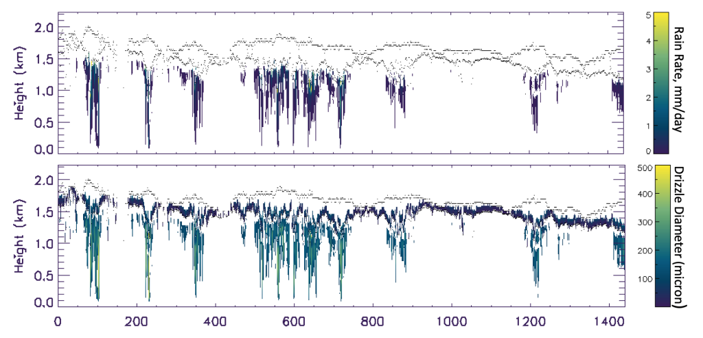
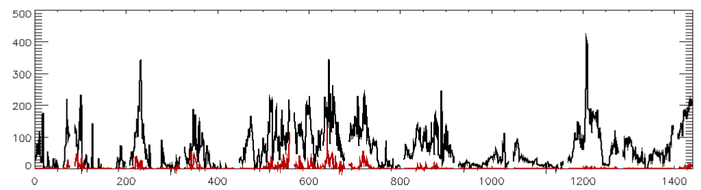
Seven years of data collected by several instruments at ARM Eastern North Atlantic (ENA) Observatory were merged to derive the following dataset that are used by performing process-level studies related to aerosol-cloud-precipitation interactions. Similar dataset were also developed using the data collected during the Cloud System Evolution in the Trades (CSET) field campaign.
- Calibrated and noise-filtered radar and lidar data
- Cloud boundaries and hydrometeor ID
- Profiles of drizzle microphysical properties below cloud base (1 minute)
- Precipitable water vapor, cloud, and drizzle water path (1 minute)
- Vertical air motion and its moments
The datasets are available upon request. Contact us for more information.
Active Remote Sensors
Cloud and precipitation radars, operating at wavelengths between 3.2 mm – 30 cm, record the raw In-phase (I) and Quadrature (Q) components of the received signal from which the Doppler spectra and its moments are calculated. Usually, the spectra and the moments are used to derive cloud and precipitation occurrences and their microphysical properties. Our group has developed algorithms to calculate the Doppler spectra from the raw I and Q data, to calculate moments of Doppler spectra, and finally to derive hydrometeor properties.
Lidars operate at much shorter wavelengths (0.3 – 2 micrometer) as compared to the radars, and hence are sensitive to aerosols and precipitation in the boundary layer. In collaboration with experts in the field, our group has developed extensive algorithms for noise-filtering the lidar data and extracting the aerosol, precipitation, and boundary layer dynamic properties. The developed algorithms have been applied to data collected by ground-based and airborne radars and lidars.
Passive Remote Sensors
Passive remote sensors such as microwave radiometers record the sky brightness temperatures at several frequencies. We use these measurements to derive the integrated values of water vapor and liquid water in the atmosphere, and to derive profiles of boundary layer thermodynamic fields. The developed algorithms have been applied to measurements collected at many different locations and have been extensively validated.
In Situ Sensors
We use radiosondes or dropsondes in many aspects of our research as they are the primary tool for characterizing the atmospheric thermodynamic structure. We also utilize data from surface meteorological stations that record the state variables at high frequencies sufficient enough to calculate the fluxes of energy, moisture and momentum from the surface to the atmosphere.
Radiative Transfer Models
The aerosols, clouds, and precipitation particles modulate the Earth’s radiation budget that is tied to the atmospheric thermodynamic fields. We use a range of radiative transfer models to quantify atmospheric radiative properties. Some of the models we use are the Rapid Radiative Transfer Model (RRTM), mono-RTM, and PAMTRA. In addition, we use Mie Scattering models such as MIEV to derive extinction, absorption and scattering efficiencies of aerosol and water particles that determine their signatures on the remote sensing instruments.