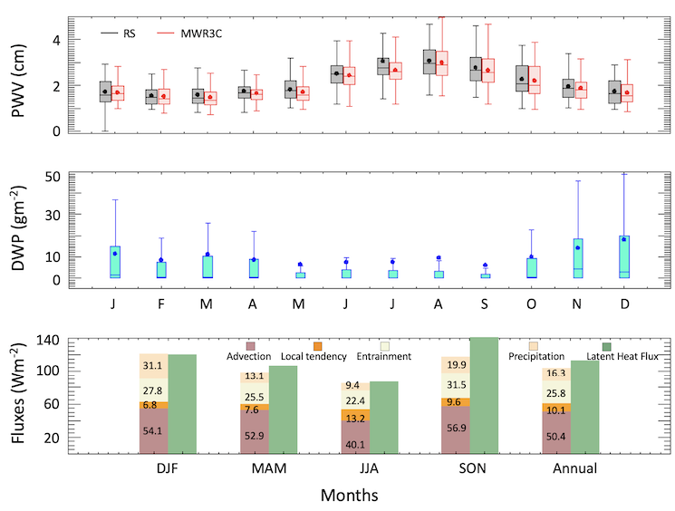
Boundary layer moisture variability at the Eastern North Atlantic Observatory
Marine boundary layer stratocumulus and shallow cumulus are maintained by boundary layer turbulence through the transport of water vapor above the lifting condensation level. Hence changes in boundary layer water vapor critically impact cloud properties. Further the marine boundary layer clouds exhibit a distinct mesoscale organization with scales of 20-50 km.
Five years of ground-based observations and reanalysis data are used to analyze the seasonal total water budget and mesoscale vapor variability. The annual cycle of the mixed layer total water budgets is presented to estimate the relative contribution of large-scale advection, local moisture tendency, entrainment, and precipitation to balance the moistening due to ocean latent heat flux on monthly timescales. When marine conditions prevail, advection of colder and dry air from the North acts as an important moisture sink (~ 50% of the overall budget) during fall and winter driving the seasonality of the budget. Entrainment and precipitation contribute to the drying of the boundary layer (~25% and ~15% respectively) and the local change in moisture contributes to a small residual part. (Published 2023).
Drizzle-Turbulence Interactions Below Marine Stratocumulus Clouds
Accurate representation of drizzle-turbulence interactions is needed for accurately simulating stratocumulus clouds in atmospheric models. Here we have utilized the long-term observations made at the Atmospheric Radiation Measurement (ARM)’s Eastern North Atlantic (ENA) site to characterize drizzle-turbulence interactions below marine stratocumulus clouds. In particular we aim to understand i) whether drizzle falls predominantly in updrafts or downdrafts, and ii) how does evaporation of drizzle affect the strength of boundary layer eddies.
Our analysis shows that a) even at strong cloud top cooling rates (<-100 Wm-2) only ~45% of the sub-cloud layer contain drizzle hydrometeors, b) weak drizzle (<1 mm day-1) falls in both updrafts and downdrafts, with the updraft fraction decreasing with increasing rain rates, c) for a similar amount of radiative cooling the downdrafts strengthened with increasing rain rates, and d) the correlation between drizzle rate and vertical air motion was highest during instances with strong evaporative cooling. (Published 2021)
Geophysical Retrievals in an Artificial Intelligence (AI) Framework for Illuminating Processes Controlling Water Cycle
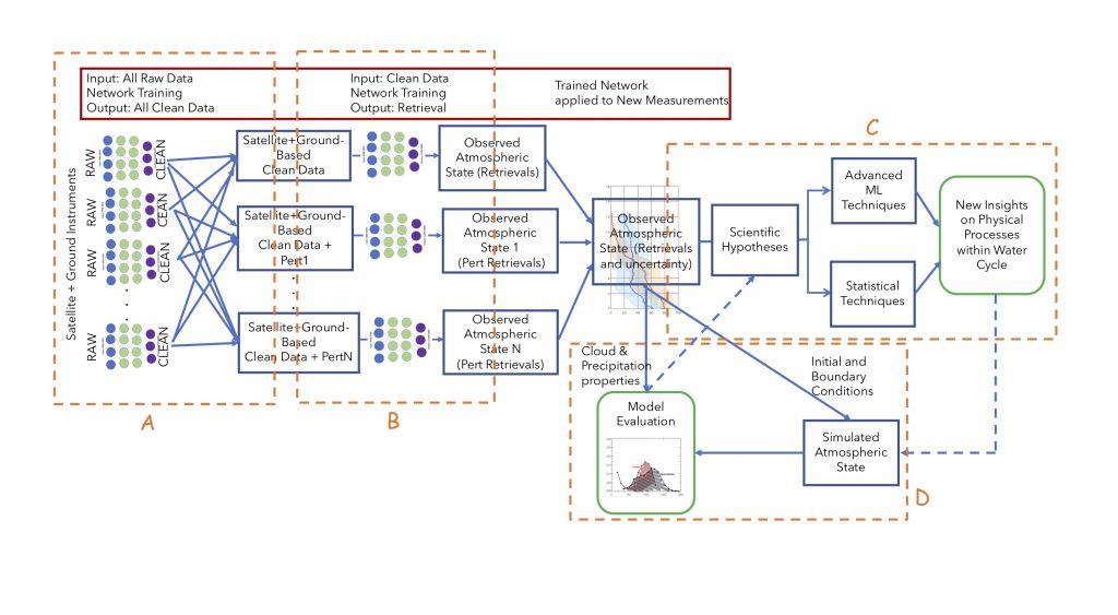
Framework that uses AI/ML and statistical techniques together with physics-based geophysical retrieval techniques to gain new insights on atmospheric processes in the water cycle and evaluate models.
We proposed an end-to-end AI-driven framework that can streamline and expedite data processing and merging data from multiple instruments to yield the state of the atmosphere related to the water vapor-cloud-precipitation interactions at various temporal and spatial scales. Together with advanced statistical techniques, this framework can be used to yield new insights into the workings of the atmospheric processes, thereby paving the way to extract the full scientific value of the collected data. It will also help to identify inaccuracies in the representation of these processes in the Earth System Models. (Proposed, 2021)
Turbulence and density currents below heavily precipitating marine stratocumulus clouds.
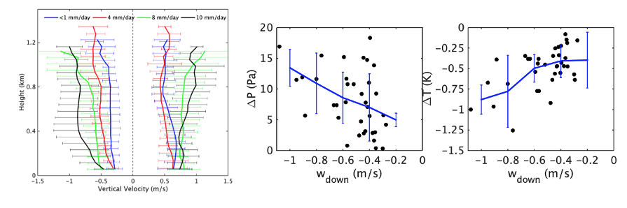
Our recent work on turbulence and cold pools in heavy precipitating clouds showed that the downdrafts get stronger with increasing rain rates, and are associated with a decrease in surface air temperature, and an increase in surface air pressure and density. The results highlight the drizzle-turbulence-surface coupling in these systems, an important aspect controlling the lifetime of these cloud systems and necessitating their accurate representation in the Earth System Models. (Published, 2021)
Characterizing Antarctic water vapor with a G-band radiometer
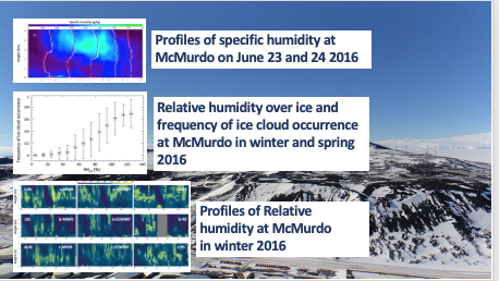
Our work using a millimeter-wave (G-Band) profiler at McMurdo showed that supersaturated layers occur during winter and spring about 20% of the time. The layers highest supersaturation occurrence of 30%-40% are typically located between 1 and 3 km. When binned by RHice ice clouds occur more frequently when the relative humidity over ice is near and above 100%. (Published, 2021)
Observations of cloud and drizzle water path in stratocumulus cloud
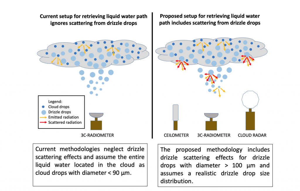
Objective: Partition cloud and drizzle liquid water path (LWP) in lightly precipitating clouds.
Approach: Combine measurements from K-band radar, Ceilometer and microwave radiometer Introduce microphysical drizzle properties in LWP retrieval. Account for drizzle scattering properties.
Impact: The retrieved cloud LWP is 7-15% less than what is found with current retrievals. Cloud and drizzle water path can be partitioned. (Published, 2020)